Call for speakers: MEDIN Open Meeting 2025 "Unlocking the oceans: managing emerging and established marine data"
Thursday 4th December 2025, Met Office, Exeter
|
|
The aims of the meeting are to highlight progress managing new or unusual marine data i.e. those data without a dedicated Data Archive Centre (DAC) and explore solutions for marine data management challenges.
Please register your attendance here and use this link to submit an abstract: Abstract submission.
|
|
|
MEDIN launch a new webinar series
|
|
|
The Marine Environmental Data and Information Network (MEDIN), is excited to announce a new monthly webinar series. Each month, this series will feature one-hour online sessions led by expert guest speakers, each focusing on specialised topics not typically covered in MEDIN’s regular free online workshops. These webinars are designed to support better data stewardship and highlight emerging tools, standards, and approaches in marine data.
|
|
|
|
Sessions will be recorded and made available on the MEDIN YouTube channel, creating a lasting resource for the marine data community.
Whether you are new to marine data management or have years of experience, and no matter which sector you work in, these sessions are designed to be inclusive and informative to all who are interested in improving the way marine data is managed and shared.
Register here: https://noc-events.co.uk/medin-2025-webinar-series
|
|
|
Time to upgrade your Metadata Maestro
|
|
|
From 1 October, the version of MEDIN Metadata Maestro that works with an older version of the MEDIN Discovery Metadata Standard (v2.3.8) will be retired and will no longer be available to download.
Maestro is our handy desktop tool for creating and managing MEDIN-compliant discovery metadata, and we want to make sure you’re using the best and most up-to-date version. The latest release supports MEDIN standard v3.1 and its features include:
- User-Friendly Interface: Categorised tabs for easy navigation and tooltip assistance.
- Compliance Checking: Colour-coded system to ensure metadata records comply with the MEDIN standard.
- Multi-Standard Compliance: Supports the creation of metadata compliant with: MEDIN v3.1, GEMINI 2.3, and ISO19115: 2003.
- Pre-Populated Controlled Vocabularies: Built-in controlled vocabularies to populate elements accurately and consistently.
- Controlled Vocabulary Caching: Users can add additional controlled vocabularies from the NERC Vocabulary Server.
- Templating: Create and use templates for consistent metadata entries.
The latest Maestro is ready to download now from the along with simple installation and user guidance.
We encourage all users to upgrade to Metadata Maestro v3.1 as v2.3.8 will no longer be supported after 1 October.
|
|
|
New MEDIN video tutorials published
|
|
|
Two new video tutorials have been published on the MEDIN YouTube channel:
|
|
|
1) MEDIN Metadata Editor: How to Import, Edit, Validate and Export existing Discovery Metadata Records
2) MEDIN Online Metadata Editor: How to Create a MEDIN Discovery Metadata Record
Subscribe to our channel to be the first to see new marine data management videos.
|
|
|
Legacy data available through British Geological Survey Offshore GeoIndex
|
|
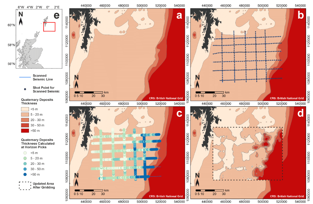
Did you know that there are thousands of kilometres of legacy seismic reflection data openly available on the British Geological Survey (BGS) offshore GeoIndex?
Looking for a way to use some of the data? Or a guided workflow to use as ArcGIS training material or for student projects?
BGS has published an open report with a guided workflow on how to spatially reference the scanned data in ArcGIS by combining it with open access bathymetry, enabling the extraction of geological interpretations and the production of point data referenced in three-dimensional space. These can then be used to create and/or update maps of subsurface geology.
Though there are limitations in accuracy when using these kinds of data, they can be used to build an initial understanding of an area’s geology before acquiring new data. See the example image below showing how some of the available data can be used to improve the resolution of regional maps, such as BGS’ Offshore Quaternary Deposits Thickness map.
|
|
|
Dissolved oxygen concentration evidence review update
|
|
The effects of climate change on dissolved oxygen concentrations in the seas around the UK and Ireland is presented in the latest Rolling Evidence Update led by Prof Claire Mahaffey, from the University of Liverpool.
Latest research indicates that ocean warming, especially in seasonally stratified regions, is increasing the risk of oxygen depletion, but the frequency of seasonal oxygen deficiency is unknown due to the paucity of data outside of the North Sea.
The review covers the following key issues:
- Coast-to-shelf and regional variations.
- Factors of oxygen consumption.
- Interaction with coastal freshwater inputs.
- Marine heatwaves.
- Ecosystem effects.
The key take-home messages are summarised on the Marine Climate Change Impacts Partnership (MCCIP) oxygen evidence review page, which also contains a link to the updated review paper.
|
|
|
Cefas's WaveNet data points to potential marine heatwave around UK coastline
|
|
Latest sea temperature data from Cefas’s WaveNet platform suggests UK waters may be experiencing signs of a marine heatwave, with temperatures in parts of the North Sea and southwest coast well above seasonal averages.
This phenomenon, characterised by prolonged periods of abnormally high sea temperatures, poses risks to marine ecosystems and economic sectors such as fisheries and tourism..
|
|
|
View the results from the full article here.
In this recent blog, Cefas and the Met Office discuss how WaveNet data is helping forecasters, local authorities, and scientists to better understand the risks and impacts of climate change on the marine environment and coastal communities.
The data supporting this article is available for download through the MEDIN portal and the Cefas Data Portal, with historic deployment data also available from the Cefas WaveNet - Map site.
|
|
|
New release: 35 years of zooplankton abundance and biomass data from the Western Channel Observatory
|
|
A newly updated edition of the long-term zooplankton dataset from the Western Channel Observatory (WCO) is now available, offering 35 years of consistent data from Station L4, a coastal site just south of Plymouth, UK. Published via the British Oceanographic Data Centre (BODC), the dataset spans March 1988 to December 2023, providing weekly measurements of zooplankton abundance (individuals per cubic metre) and biomass (carbon, µg C m⁻³), derived from formalin-preserved samples collected using 50 m vertical net hauls (200 µm mesh).
The data are the product of a sustained monitoring effort by researchers at Plymouth Marine Laboratory (PML) and represent one of the longest-running zooplankton time series in the world. To ensure temporal continuity, only taxonomic groups that have been consistently identified across the full time series are included. This means that, while the dataset is a subset of the full species list, it retains all major contributors to biomass and abundance. This approach allows robust comparison across decades and supports a wide range of interdisciplinary applications, from tracking climate-driven shifts in plankton communities to modelling carbon fluxes and food web dynamics.
|
|
The dataset is freely available under the UK Open Government Licence (OGL) and is published with the Digital Object Identifier (DOI). Users are encouraged to cite the dataset in publications as: McEvoy A.; Atkinson A.; Beesley A. (2025). Abundance and biomass of consistently identified taxa from net hauls at site L4 off Plymouth, UK from 1988–2023. NERC EDS British Oceanographic Data Centre NOC. Proper citation not only gives due credit to the contributors but also helps track usage and increase discoverability.
The L4 zooplankton dataset complements a broader suite of environmental data from the WCO, including essential ocean variables, nutrients, phytoplankton, and benthic observations with additional information and background found at westernchannelobservatory.org.uk/l4_zooplankton.php. Researchers and other interested parties with questions or plans to use the data are encouraged to contact the originators to ensure correct interpretation and application of this unique time series.
|
|
|
OceanWise and UKHO continue to strengthen global tide and sea level data coverage with new installation on Grand Turk Island
|
|
OceanWise, as part of its framework agreement with the UK Hydrographic Office (UKHO), has expanded global tide and sea level monitoring with the installation of a new Marine Environmental Monitoring Station (MEMS) in Grand Turk, part of the Turks and Caicos Islands.
This latest deployment builds on the successful rollout of MEMS at sites across the Caribbean, South Atlantic, and Indian Ocean, further strengthening the UKHO’s global programme.
|
|
|
|
The MEMS tide gauge installed in Grand Turk will help fill a critical data gap in the region, providing high-quality, real-time sea level and tide data to support safe navigation, charting, and wider environmental applications.
“We’re proud to continue supporting the UKHO in this important programme,” said Caroline Levey, Managing Director at OceanWise. “The installation at Grand Turk demonstrates the practical benefits of collaborative data collection – helping to improve safety and resilience in coastal regions particularly vulnerable to changing ocean conditions.”
The Grand Turk installation represents another step in UKHO’s long-term commitment to improving access to accurate hydrographic data, particularly in remote or underserved locations. Each MEMS station contributes to global maritime safety, disaster preparedness, and evidence-based decision-making – and data from the stations are already being shared via the GLOSS (Global Sea Level Observing System) network.
OceanWise’s role in the programme includes the supply and configuration of equipment including tide gauges, met stations, commissioning, training, and the integration of real-time data into the OceanWise Port-Log platform, ensuring information is reliable, accessible to whoever needs it, and secure.
The Grand Turk installation is part of a wider strategic vision to support the International Hydrographic Organization’s S-100 framework and modernise the way sea level data is captured and shared worldwide.
|
|
|
Improvements underway for the Offshore Wind Environmental Evidence Register
|
|
|
The Crown Estate are creating a new and improved digital version of the Offshore Wind Environmental Evidence Register (OWEER).
OWEER is an external register that highlights and prioritises evidence needs across five areas: marine mammals, fish, benthic habitats, seabirds, and the wider ecosystem. It also tracks completed and ongoing offshore wind research, with the most recent update published in February 2025 (version 6.)
|
|
|
|
The outcome of this work will be a digital tool, hosted as part of the Offshore Wind Evidence and Knowledge Hub (OWEKH) initiative, with the content being easily accessible and searchable, helping to coordinate, prioritise and reduce duplication across organisations interested in offshore wind evidence and research.
The Crown Estate wants to make the tool as useful as possible, so are asking for individuals across different types of organisations, who currently commission or run projects, or have an interest in research around the environmental impacts of offshore wind in their roles. They would like to chat with you about topics you are interested in, what information you need to get from OWEER and what you would like to see improved. You would therefore be invaluable in inputting to the final digital tool design, and your help in testing out the new functionality that we build would be greatly appreciated.
In terms of time commitment - The Crown Estate expect this will be about 1 hour a month of your time over a Microsoft Teams meeting, from late August until the end of the year 2025.
If you are interested in getting involved in this initiative, or know people in your organisation or wider network that may be willing to contribute, please do get in touch at your earliest convenience with gabriella.gilkes@thecrownestate.co.uk or francesca.downey@atkinsrealis.com.
|
|
|
We look forward to working with you on this and really thank you for your input.
|
|
|
|
A brand-new exhibition, titled ‘100 Year of RRS Discovery’, opens at Discovery Point in Dundee on the 13 September 2025 as part of the National Oceanography Centre's (NOCs) wider celebration of the 100th anniversary of RRS Discovery’s first scientific voyage. The exhibition celebrates a century of exploration and innovation embodied by these iconic research ships, and the people on board who continue to push the boundaries of ocean science.
Read more about it here.
|
|
|
Introduction to Coastal and Marine GIS - Training Course
|
|
Looking to understand marine spatial data and its application within a GIS environment?
The Introduction to Coastal and Marine GIS course will provide you with the background and skills necessary to utilise spatial data as a decision-making tool in marine planning, conflict management and environmental management.
|
|
Delivered by ABPmer’s GIS consultants - specialists in the coastal and marine sector - and GeoData’s experienced GIS trainers, the three-day course uses case studies and hands-on activities to provide you with the background and skills necessary to utilise powerful GIS tools to support sustainable development decisions.
Using the open-source QGIS v3.x, the course is structured around modules that cover various GIS concepts and techniques. As well as introducing marine data and GIS, the course considers common problems faced when mapping coastal and offshore environments. There is also an opportunity to discuss specific spatial data issues with our specialists.
At the end of the course delegates will know and understand:
- What GIS is; what spatial data is; raster and vector data models
- The core tasks involved in GIS analysis, including acquisition, storage, management, manipulation and presentation
- The core functionality of QGIS
- How to import data and handle tables, including selections and queries
- Georeferencing raster images
- The creation and editing of spatial data
- How to visualise spatial data and produce maps and charts
- How to manage spatial data and use Geopackages
- Basic geoprocessing tasks
- Coastal and marine GIS data and its applications
Upcoming course dates:
- 14 – 16 October 2025, online
Fee: £695 (no VAT)*
*Standard price for one delegate; full price list available at booking.
For more information, or to book, visit the ABPmer website.
|
|
|
|
Marine Archaeology Conference
|
|
|
The Marine Archaeology Group online day conference titled
"Offshore development: shaping the legacy for marine archaeology"
is taking place on 27 November 2025, 10:00 - 15:30 GMT and is open to non-members.
Find out more and book your space.
|
|
|
Register now for the next free MEDIN workshop
|
|
|
The Marine Environmental Data and Information Network (MEDIN) holds free training workshops periodically throughout the year to improve the uptake, knowledge and use of MEDIN Data Guidelines and the MEDIN Discovery Metadata Standard (and associated tools).
|
|
The virtual/online workshops titled: ‘Marine Data Management, Governance and the MEDIN toolset’ are hosted on OceanTeacher Global Academy and are run over five days, with interactive discussion sessions and presentations in the mornings and independent study in the afternoons. Workshops are modular, allowing attendees to attend all, or specific parts of the training, depending on individual requirements.
The next marine data management training will take place 13th-17th October 2025 online. Register here using the enrolment key MEDIN102025.
|
|
|
|
|